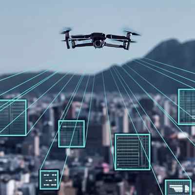
Aerial Intelligence Surveillance
Aerial Surveillance: Real-Time Intelligence, Strategic Oversight
Aerial surveillance remains one of the most impactful applications of UAV technology. Traditional surveillance methods—using manned aircraft or fixed cameras—are limited in flexibility, coverage, and cost-efficiency. In contrast, International Armour UAV systems provide scalable, real-time monitoring across wide geographical areas.
Equipped with high-resolution cameras, infrared sensors, and AI algorithms, our drones autonomously detect anomalies and potential threats with precision. AI-powered data processing reduces operator workload by filtering irrelevant information and prioritizing actionable insights.
These UAVs seamlessly integrate into centralized monitoring systems, creating a live data feedback loop that enhances both tactical operations and long-term strategic planning.
Key Benefits:
- 24/7 real-time aerial monitoring
- Seamless integration with existing security infrastructure
- Reduced personnel costs and increased coverage
- Enhanced anomaly detection using onboard AI
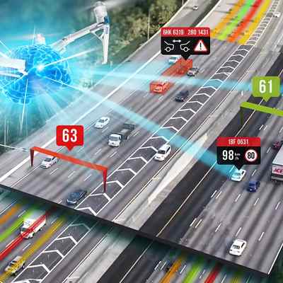
Traffic Monitoring: Unlocking Smart Urban Mobility
Cities worldwide are facing escalating traffic congestion, leading to economic and environmental strain. Traditional traffic sensors offer static, partial views, our UAVs offer dynamic, aerial visibility.
Our drones provide real-time traffic analysis over vast urban areas. Integrated machine learning models analyze live data to identify congestion patterns, accident locations, and optimal traffic flow strategies.
Beyond monitoring, our UAVs contribute to predictive analytics for long-term infrastructure planning, smart traffic light optimization, and enhanced emergency routing.
Use Cases:
- Traffic pattern forecasting
- Real-time congestion mapping
- Accelerated emergency response
- Long-term urban planning data
Transforming Aerial Surveillance and Services Through Advanced UAV Technology.
International Armour is redefining the future of surveillance, monitoring, and emergency response through the strategic deployment of Unmanned Aerial Vehicles (UAVs).
Our advanced drone systems integrate cutting-edge sensors, AI-powered analytics, and autonomous navigation to deliver real-time data, enhance situational awareness, and improve decision-making across multiple sectors.
From national security and infrastructure monitoring to environmental protection and disaster response, we offer scalable, intelligent UAV solutions that empower governments, industries, and humanitarian missions worldwide.
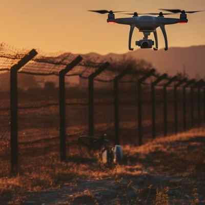
Border Control Drone: Autonomous Surveillance, Elevated Security
National borders demand continuous protection—often over harsh terrain and remote areas. Traditional patrol methods can be slow, costly, and reactive.
We offer long-range, autonomous UAVs equipped with thermal imaging, radar, and motion sensors, capable of detecting human movement, vehicles, or illegal activities in real time—even in low-visibility or adverse weather conditions.
Our drones patrol designated zones without the need for constant human oversight and communicate instantly with control centers to trigger alerts and mobilize responses.
Advantages:
- 24/7 autonomous patrolling
- Detection of illegal crossings or contraband
- Integration with ground security infrastructure
- Faster, data-informed deployment of resources
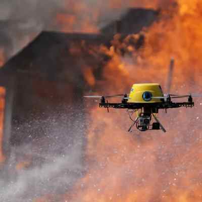
Emergency Response Drones: Rapid Aerial Support in Critical Moments
In disaster scenarios, situational awareness saves lives. Whether it’s a natural disaster, industrial incident, or humanitarian crisis, response teams require fast, accurate information.
The UAVs provide immediate aerial overviews of affected zones, often reaching locations inaccessible by ground teams. With thermal imaging and GIS mapping, responders can identify heat signatures, assess damage zones, and coordinate rescue efforts.
Our drones can also deliver medical supplies or essential equipment, bridging logistical gaps in hard-hit or isolated areas.
Capabilities:
- Search and rescue with thermal vision
- Real-time damage assessment
- GIS-enhanced coordination
- Delivery of critical supplies to remote zones
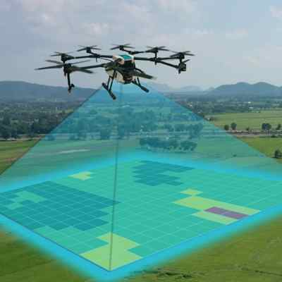
Environmental and Agricultural Monitoring: Smarter, Sustainable Stewardship
Drone technology is transforming how we protect the environment and manage agricultural operations.
Environmental agencies use our drones to monitor deforestation, wildlife, pollution, and illegal land use—gathering more granular, non-intrusive data than satellites. In agriculture, drones monitor crop health, irrigation efficiency, and soil quality using multispectral imaging.
AI-powered analysis helps detect early signs of crop disease, forecast yields, and optimize the use of water and pesticides, supporting both productivity and sustainability.
Applications:
- Ecosystem health tracking
- Anti-poaching and deforestation patrols
- Crop and soil condition monitoring
- Predictive farming analytics
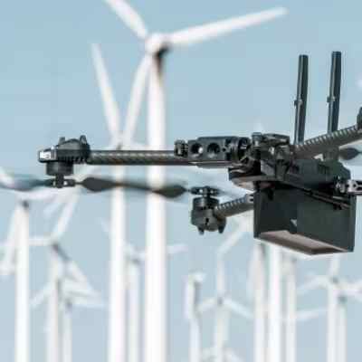
Infrastructure Inspection: Risk-Free Evaluation at Scale
Inspecting infrastructure like bridges, pipelines, wind turbines, and power lines often requires human workers to enter hazardous zones. Our UAVs eliminate that risk by conducting remote, high-definition inspections.
Equipped with thermal and visual imaging systems, our drones detect cracks, corrosion, leaks, or temperature anomalies before they become costly failures. AI analysis accelerates reporting and reduces the need for manual interpretation.
Benefits:
- Remote inspections of high-risk areas
- Early anomaly detection through AI
- Reduced operational downtime
- Lower inspection costs and enhanced safety
Mapping &
GIS Services
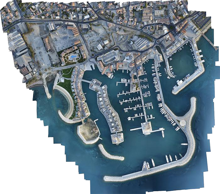
We utilize drones, specifically small unmanned helicopters and fixed-wing aircraft, to conduct aerial surveys and mapping. This process involves capturing low-altitude aerial photography using geometrically calibrated cameras and employing photogrammetry techniques.
These images are used to generate detailed 3D digital elevation and terrain models, as well as high-resolution orthophoto mosaics.
One key advantage of drones is their rapid deployment capability, even under cloudy conditions, allowing for flexible and efficient operations.
Furthermore, because the drones operate at lower altitudes compared to conventional aerial photography, they provide superior resolution and accuracy.
The individual images captured can be corrected for terrain elevation variations and adjusted for any color differences caused by changing weather conditions. These processed images are then seamlessly integrated into a comprehensive orthophoto mosaic.
Since the resulting image is fully scaled, it can be directly imported into CAD or GIS software, serving as a precise backdrop for measurement, analysis, or mapping tasks.
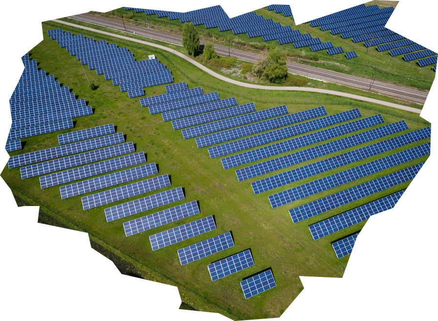
Drone use in
Solar Parks
Optimizing Photovoltaic Park Operations with Drone-Based Aerial Services
As the global demand for clean, sustainable energy sources continues to grow, photovoltaic (PV) solar parks are expanding rapidly, particularly in regions with abundant sunlight and open space.
Efficient operation and maintenance of these vast solar installations are essential to maximizing energy output and minimizing costs.
Aerial services using drones have emerged as a valuable solution, offering precise, rapid, and cost-effective monitoring and inspection options for photovoltaic parks.